
|
|
July 31st 2019 promised to be a Classic summer's day with hours of sunshine, temperatures over 20C and humid with light winds, it was the type of day I long for and don't like to waste, after all, it had been a week since I had flown my drone and I was eager to get flying again in such good weather while enjoying the hot sunshine, the problem was where was I going to film? it was at this moment that I got a phone call from drone pilot and photographer Nigel McFarland from AerialVisionNI with an opportunity to film a subject matter I have always wanted to do justice too. Nigel informed me that Broighter Gold Rapeseed near Roe Valley were cutting barely today with their combine harvester, Nigel knew the owners so they were game for allowing us to film the harvest with full permission to do whatever we wanted, well I jumped at the chance, Nigel provided me with the directions and I made my way to Broighter Gold for midday. I met the family who were lovely people, I was impressed by the landscape here, it really couldn't have been more perfect for filming.
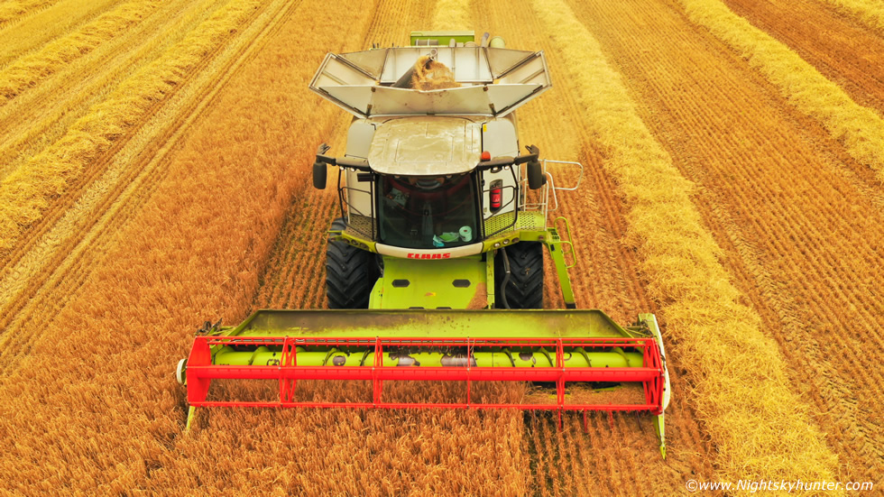 |
I have filmed a combine in action before a few years ago with my old Phantom 3 Advanced, however the field was small, hilly and was criss-crossed with power lines which made flying more intense and the wires cluttered the scene. Furthermore the drone code states that in the UK I need to be 50m from any object or person not under my control so this limited the potential of the footage, since then I've always wanted another chance to do it properly. Today that chance had come, thanks to good people. The fields here were flat and massive with a clear horizon on three sides, these were proper barley fields which looked like a rich combination between orange and gold colours, to one side was Lough Foyle and Co. Donegal while to the other was the awesome sight of Binevenagh, the area was absolutely perfect and photogenic. Now that I had full permission I could fly as close as I safely wanted to, this way I could get more dramatic footage.
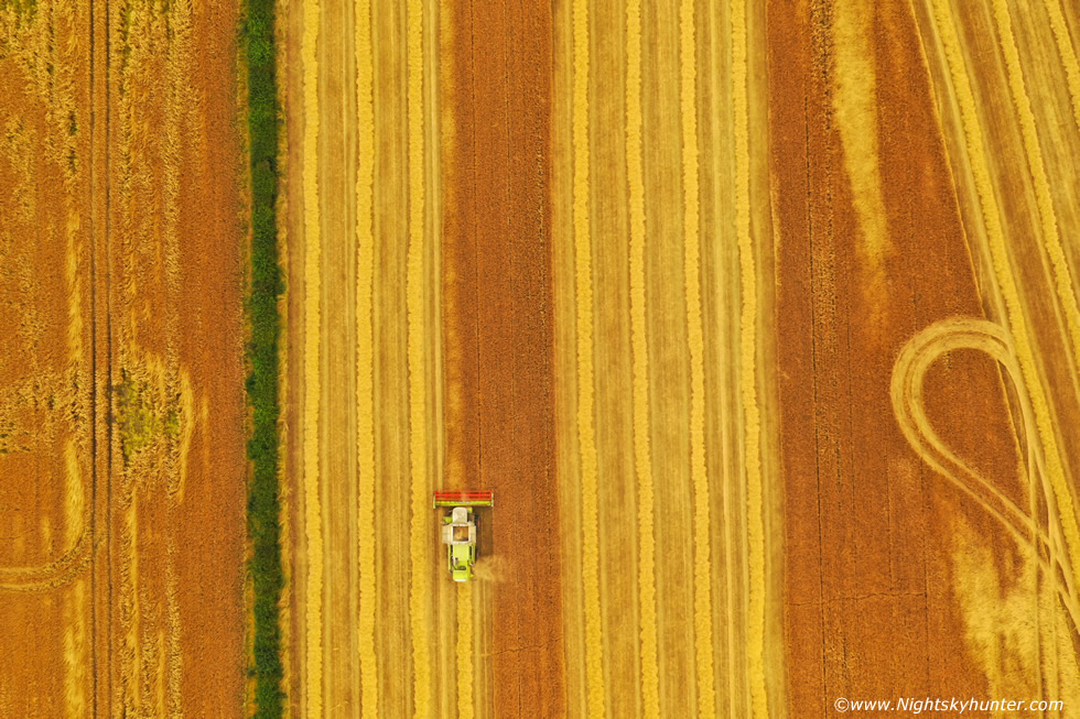 |
We spent hours on location, the hazy clouds broke into blazing sunshine with blue skies and standing among the barely felt humid and stifling as the combine worked the landscape, it was a brilliant Summer memory. I burned through three batteries and acquired footage that I was more than happy with. The sweat was dripping from me and at times my Mavic 2 Pro was 50cm above the crop while flying backwards tracking the forward moving combine at close range, there was no room for error, if I had crashed the drone in the barley the combine would have mauled it in the rotating blades so these moments of finesse took high concentration and hence the sweating, however it all worked out perfectly and I was well pleased with the results. Once again I would like to thank the Kane family for such a great opportunity and to Nigel for the welcome invite. These aerial stills don't do the day justice however if you watch my full video you will be able to appreciate the atmosphere so much more.
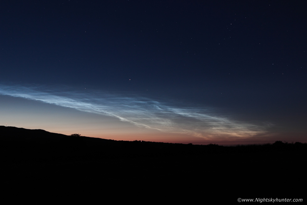 |
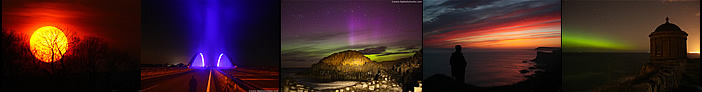
The 2019 NLC season has been quite spectacular with many large type 4 and type 5 displays dominating the night time Summer sky at random intervals, some of these I witnessed myself and documented on camera and I even acquired my finest NLC time lapse to date at Mussenden Temple which completed the season for me. We had several nights of back to back clear skies with no NLCs present and the night of July 6th 2019 looked to be clear once again so I was on stand by. I was in Cookstown looking out the windows checking the sky while monitoring activity on social media from other NLC observers across UK and Europe. At midnight reports arrived from the UK, the images I saw looked like a sorry display so I paid it little heed, from what I saw online it wasn't worth my energy driving out to time lapse something so unimpressive. Half an hour later I got a message from John C. McConnell saying it looked decent with good structure so I looked out the window one final time, this would be my decision maker, if I wasn't impressed I was staying in this night. Once I saw it I wasted no time changing into warmer clothes and boots then raced out the road in a panic. This display was a beauty, I noted that it was of low elevation and from my position among houses it could have been missed completely, however once I made it onto the open road the spectacle could be seen showing off along the N to NW sky sectors, I admit that I was impressed, but where to shoot it?, there isn't much foreground around here so I got off the main carriageway and headed into the countryside outside Cookstown.
I drove along twisting country roads which were pitch black at night, luckily the roads were quiet with no other activity so I felt like I had the country to myself, all I was after was an open view across the land to shoot the display, a location free from wires, no tall trees, and not close to farm houses. I took a bend in the road and there was the perfect field I wanted, with luck the farmer had left the gate wide open after it had been cut, I decided I would drive straight into the field, the grass was dry and hard from all the recent good weather, so there I was with van parked in a field in the middle of the night. The field was expansive, flat, open and offered a perfect uninterrupted view of the NLC display, this was a perfect find. I set up my DSLR with 24-70mm F/2.8 lens and began shooting a time lapse.
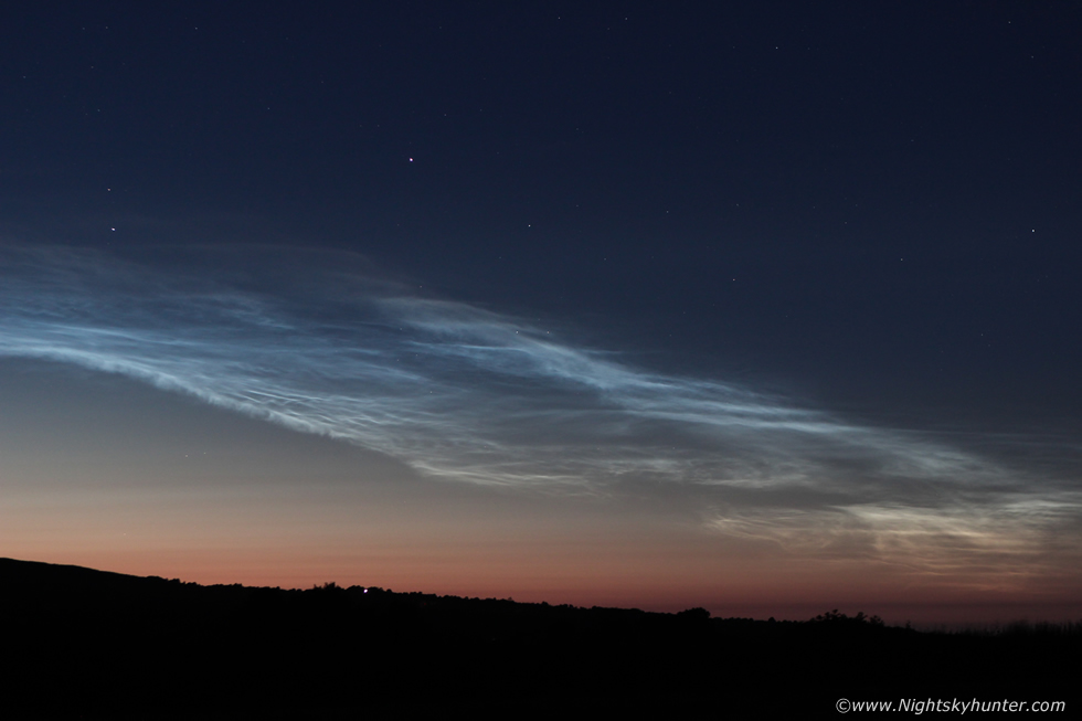 |
As the camera took exposures the night around me was quiet and still, I could hear distant sheep and cattle which was a sound I found very relaxing. A slightly cool NWly breeze kept the dew off my lens so there was nothing to worry about, it was just a matter of letting the camera do its thing. The sky had the classic late Summer look to it, the northern half of the celestial dome still had that advanced twilight glow where the NLCs resided while the southern sector was now getting much darker with more stars visible and the Milky Way much more prominent than before, my eyes were drawn as always from Cygnus through Aquila into Scutum and Sagittarius while to the SW was Scorpius with red Antares, I observed several bright iridium flares and a passage of the ISS. The NLCs themselves were absolutely gorgeous, this was not a massive display or exceptionally bright, however size isn't everything. The NLCs must have peaked at type 3.5 and faded to 3 but they posessed wonderful structure in the form of intricate ghostly bands, knots, ripples, waves and whirls with a colour range from silver to blue to orange from W to E. I could see the structures moving in real time however the view through my large binoculars was beyond words, it seemed the luminous NLCs were alive through the glasses. I shot two time lapse sequences at two differing focal lengths which turned out great, once they faded away into the background sky I headed home at 02.30 BST and went to sleep feeling happy and content, check out the complete time lapse.
 |
As luck would have it the models were showing an active week of convective action with at least four days in a row of potential and after a quiet season I was keen to hunt more storms, I still hadn't captured the kind of cloud scenes I wanted and I had yet to acquire a decent time lapse of a storm to make my season, I was feeling motivated and dedicated and was determined to make the most of this four day event, I figured there was a fair chance of seeing at least one decent skyscape during that week as long as I remained committed, and so began another week of obsessing over charts and watching radar.
August 4th was the first event, Roisin and I had planned to chase this afternoon, we were up early that Sunday morning and enjoyed a caramel late (Roisin takes soya) in Ground Cafe where I brought my lap top to study the day's set-up. This looked to be a warm core set up with low CAPE but good shear, however I was already not liking the way things were going, these warm cores often brought a lot of cloud which meant grey skies and the models were showing a lot of precip, it was already shaping up to be a wet uneventful day. However storms did fire exactly in the area the AROME model predicted, just a little later than expected and so rapidly I barely had time to react. By 7pm a line of storms had formed to the W of Omagh and extended all the way to the Donegal coast, Roisin and I left Cookstown during the late evening and chased out the Omagh road, we pulled over near An Creggan and watched the line of storms far off in the distance, they where too distant and fast moving to chase and the sky was very overcast and grey, we watched anyway as they departed, Paul Martin captured a high based shelf cloud from them earlier near Omagh but now they were gone. We did get hammered by big showers with nasty cores for the rest of the evening however there was nothing photogenic so we headed back home, tomorrow would be another day.
August 5th looked much better, 500 CAPE well into evening time, LIs -2, good solar heating, and lift from an advancing short wave trough, there was no shear however convergence looked to be the main focus point for cells. The general consensus was that discrete cells could form close to the leading edge of the front. GFS and AROME suggested that the Sperrins, Lough Neagh, Antrim and Down would be the main target areas, I liked the signatures for Lough Neagh so I decided I would make this my target area for the day. The sun was bright and strong with blue skies well into the afternoon, a few showers formed on radar over Tyrone and advanced to the E, some forming red cores, it looked like things could be kicking off and judging by their current motion they would be crossing Lough Neagh as a line of cells, I decided to head to the lough, I parked at Ballyronan Marina and waited, I saw the line approach, no gust front or any structure present, then it passed over as a grey mess. I waited for the flanking are to move over the water just in case but there was none, just a big grey mess with weak rain, there was simply nothing to shoot. I felt silly sitting their with all the gear ready and not one decent cloud in the entire sky. So I waited and waited, and waited some more, new showers/cells arrived and they were absolute rubbish, honestly some of the worst convective skies I've ever seen, the clouds were lifeless, dull, high based and low topped, nowhere near high enough for thunder and quite frankly they were just plain ugly. It was late afternoon and prime heating and all I could see was wasted CAPE, at this point my temper had went, yet another day of let downs for this storm season, what a joke, not even a decent towering cumulus in sight, I decided I had had enough of this nonsense, I was getting tired waiting around and I was wasting my time so I decided I would head home to Maghera, the time was 16.30 and I was getting concerned about early rush hour traffic on the roads.
When I left Ballyronan I should have took the option for Magherafelt then Castledawson roundabout but for some reason I headed for Toome thinking I could fly out the Toome line before rush hour kicked off, well that was a big mistake. I got trapped in slow moving traffic, the cars were only crawling and at times stationary with no movement at all, I even switched off the engine a few times to save diesel, it was a nightmare, all due to road works and rush hour, I reckoned I spent a good hour before I made it from one side to the other, by which time I was furious, more so at myself for taking this route when I should have know better, what a compete waste of time. It just felt like one of those days when nothing went rite, the sorry excuse for a sky, no storms and now traffic james, I just wished I could get home and escape from it all. To make matters worse I saw several big cells over the Sperrins, I knew I would never get them trapped in this traffic, it was a terrible feeling, but then I had a second look, their anvils were soft, fuzzy and pathetic, the cells were a joke. I cursed the sky, I cursed the 2019 storm season and I cursed the traffic, I gave up and once I made it through I headed home and lay down on bed in rotten form.
Before 19.00 I took another look at radar, the front was close to hitting here, it looked like an evening of rain, but rite on the leading edge cells were forming, a cluster extended from the Sperrins to the Lough and were moving NE, they actually looked good, the view outside showed high robust updraughts, actually the sky really seemed to be talking so I decided to take one last chance at it and drove out the road. I parked outside Mahera and watched a line of towers to my N which seemed to be quiet, then suddenly I heard thunder!, I second guessed myself not believing it, then thunder rumbled again, it was to my S and from that cluster on radar, I knew I had a feeling about that one.
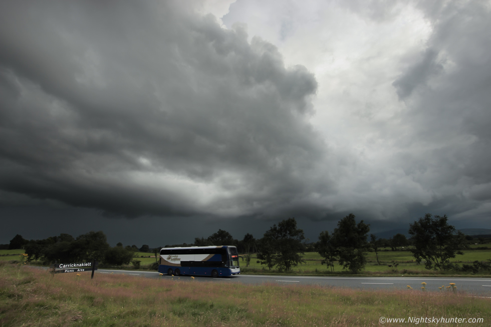 |
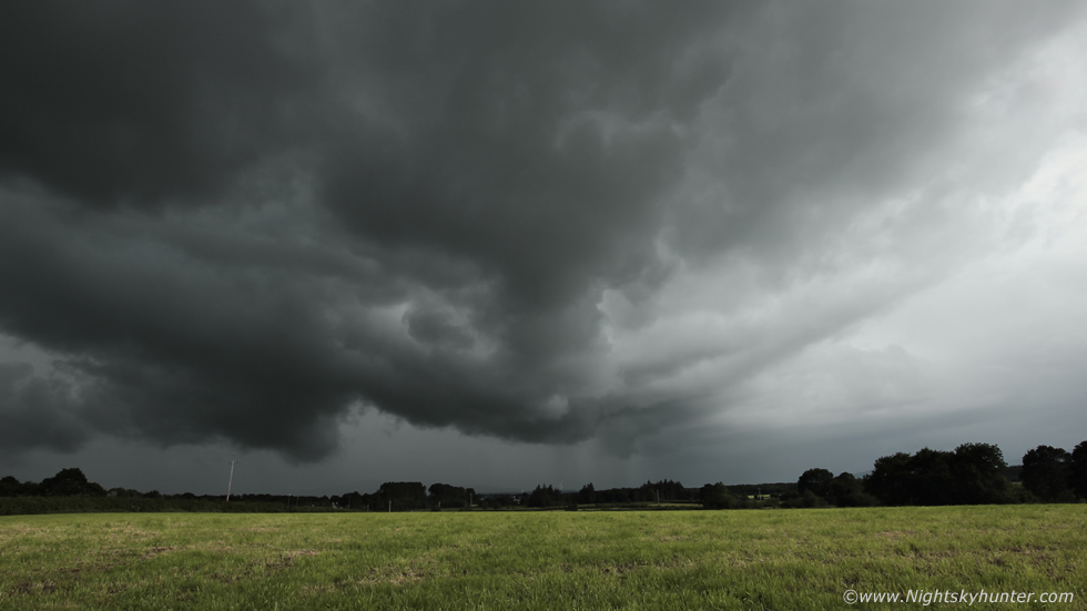
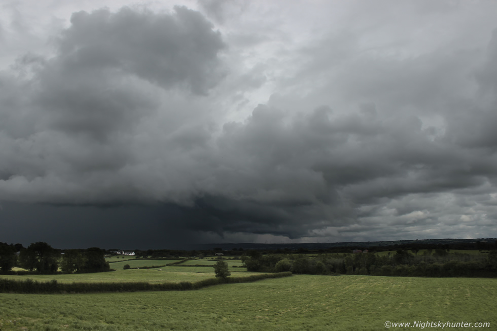
So I drove to the S of Maghera and took the junction for the Glenshane Road and headed in that direction, less than half way to the Castledawson roundabout I could see the storm filling my windscreen, it stretched across a large area of skyline and looked mean as hell with heavy black clouds contrasting against the green fields, suddenly my mood shifted from frustration to happiness, I had a storm close to home. I pulled over at Carricknakelt picnic area for a few shots of the outflow region of the storm. This was the W side of the cluster, the E side extended out of frame to the left across Lough Neagh, I took a few rushed shots from here however I didn't like the trees getting in the way, however I captured the 212 translink so I kept this one. I wanted a less cluttered view so I got back in the van, reversed, and drove back along Glenshane road again, with these outflow dominant storms your best bet nine times out of ten is to stay ahead of them for structure on the forward end, I drove perhaps 1km east then pulled over beside a gate at the road side.
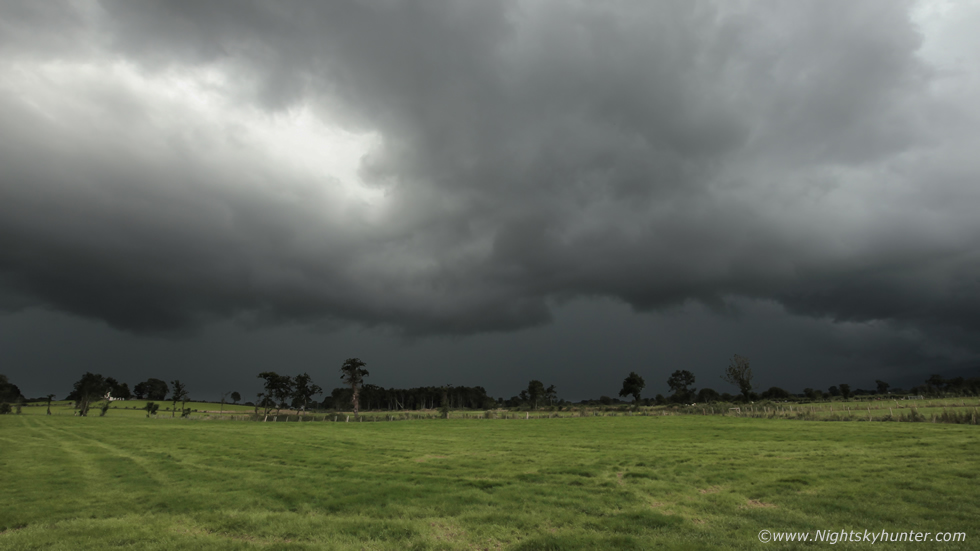 |
This was a much better position, my new vantage point offered a great unobstructed view of the storm with over 50% of the entire cluster in a clutter-free area for photography. The storm was inching closer so there was no time for setting up a tripod or shooting time lapse, this was a storm for stills only so I leaned on fence post to steady my hand and began taking stills.
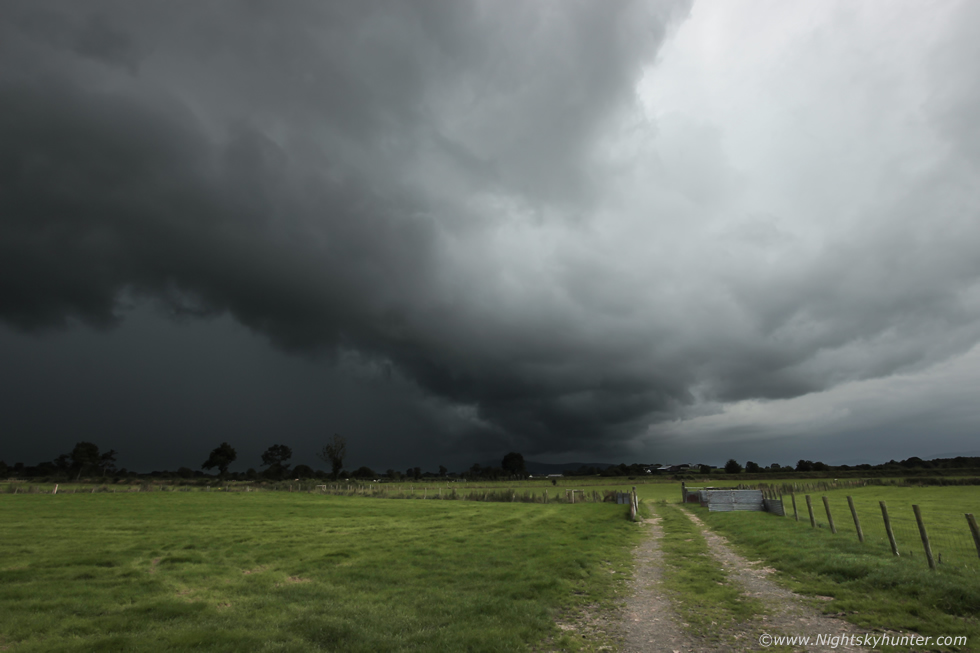 |
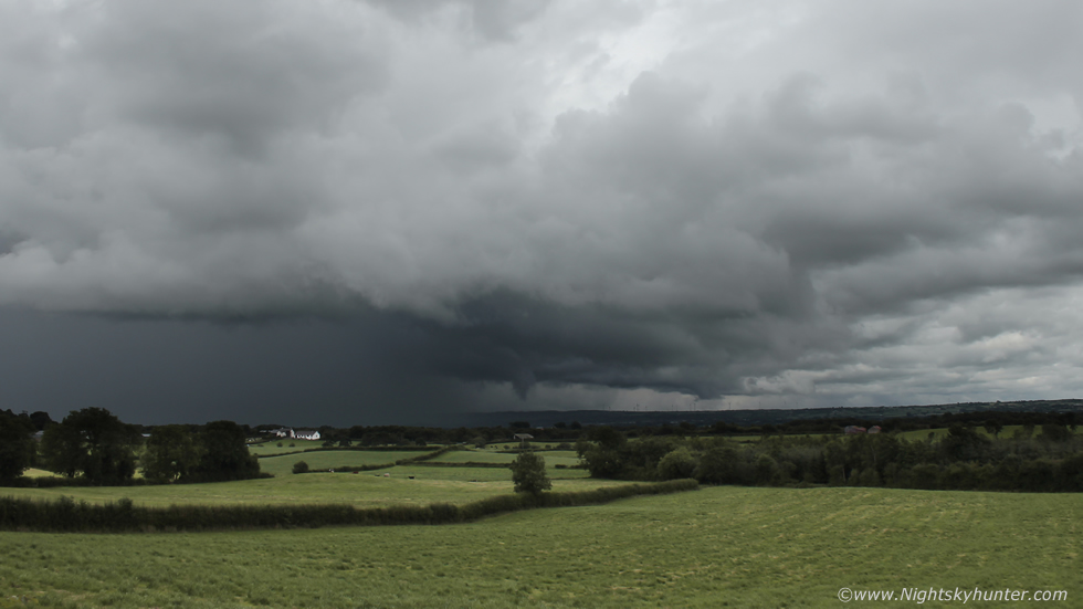
Panning 90 degrees to my right revealed a dramatic gust front on the leading edge of the storm, the clouds were solid and very black, I
 |
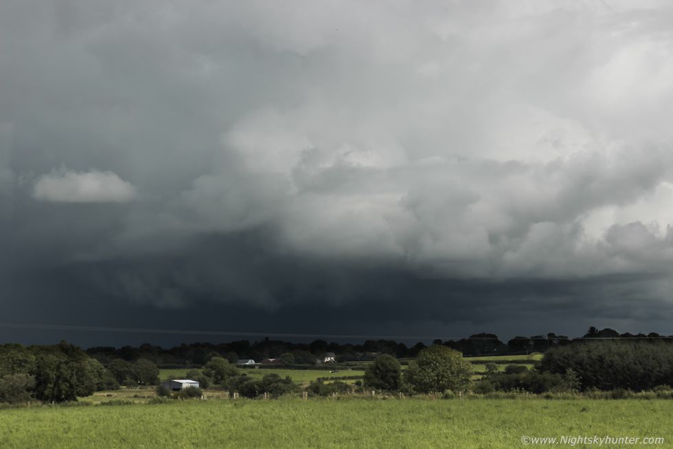
Another stop near the Glenshane fly over, I ran into a field and grabbed a few more wide angle stills, the storm was now a big outflow cluster but it still looked dramatic over the lush countryside.
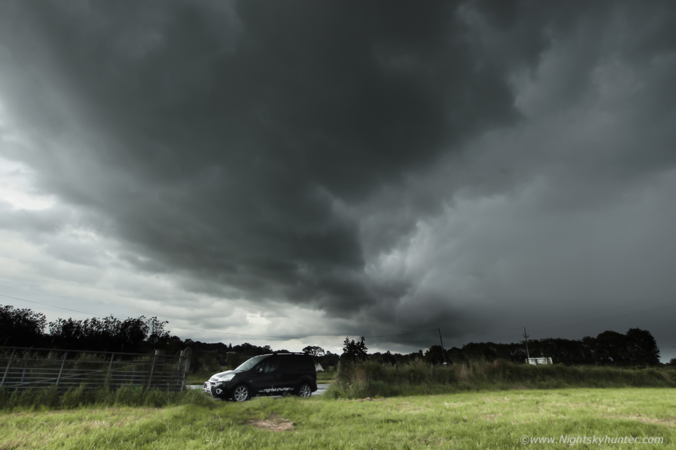 |
Turning to my left showed the other side sporting a gust front about to over take my van. The thunder had stopped but heavy rain become the new order of the day and I mean proper heavy rain with big water droplets which soak you within seconds, and that's what happened, by the time it took me to run from here to the van I was drenched. I figured I probably had seen the best of it but decided to keep chasing anyway just in case, I took a detour through the countryside, through Maghera, then drove out past Swatragh and got ahead of it again, for a few minutes it had a mean guster on one side then it got filled in again by rain. I stopped the chase outside Garvagh, I ended up on some back road and watched as the gust front swept over a solitary wind turbine and I never saw it again. I drove back home through torrential rainfall which flooded the roads, I had trouble seeing out the windscreen at one point and on two occasions I almost aquaplaned but I slowed my speed and all was good and I made it back for 21.00. This day sums up storm chasing in a nut shell, a vast range of emotions and mood swings, then a failure turns around in the last minute to an unexpected success, the gust front over the field was my trophy catch of the day but it was hard earned, as soon as I downloaded my images I re-charged the batteries and began checking the models once more for tomorrow looked to be an even better set-up.
August 6th looked to be one of the best set-ups of the year, +1000j/kg of CAPE, LIs -3, good solar heating, low cloud bases, decent moisture, -30C air aloft with very good lapse rates. The best of the shear was present over E and SE N. Ireland during the evening so for the midlands it looked to be a day of good pulse storms, models were showing several well defined convergence zones setting up and with great instability these parameters would help to compensate for the lack of shear. GFS and AROME and Met Office were all going for strong high precip storms with a yellow warning issued by the latter. On the morning of the 6th I was up early studying models and trying to pick a location most likely to produce action. I was in conversation with Owain Rice over these matters and we discussed the pros and cons of this set-up at length. The Met and AROME were all jumping on Lough Neagh and Sperrins then later Antrim and Down, GFS was going for cells anywhere which was reasonable enough given the nature of pulse convection. In truth it would be a case of radar watching and nowcasting, in the meantime I studied all the soundings from various parts of NI, it seemed the Lough, E, SE and NE had the best skew-Ts with the worst to the NW. With good CAPE arriving by midday it wouldn't be long for showers to form with stronger solar heating by 13.00 I was expecting to see action soon.
By 13.00 a nice cluster of single cells popped up to the N of my home town of Maghera, they quickly began sporting red cores and although they were 'quiet' so to speak Owain reckoned they could spark further to the NE of town. I went to the window and got a visual and immediately liked what I saw, several big white towers were merging into a cell with precip core on the rear, ahead was a very strong updraught catching the bright sun with clear air ahead of it, below the base was very dark and well defined, this didn't look like a cell about to turn outflow, it seemed young and healthy with plenty of inflow features, I suspected Owain was bang on, this cell could spark at any minute.
 |
I drove out the Crewe Road and pulled over for a look at the cell, this was at 55mm into the base of that tall leading updraught, it looked solid and tightly held together, the updraught base had very nice structure with a lot of interesting inflow features which were clearly rising and building, it was moving away from me at a very slow pace so I decided it was a perfect target for chasing. I followed it out the back roads past Culnady and raced NE through numerous country roads, the entire time I had it within sight through the windscreen and I was gaining ground fast. Periodic scud-like lowerings twisted below the base with short life spans and I began to sense that a funnel was possible at any moment.
 |
I was now to the NE somewhere in the countryside to the W of Ballymoney, I crested a hill and was offered a great view of the cell, I managed to get the van parked on a grass lay by and got out for a look. Thunder rumbled across the countryside, then more thunder, this was heaven, Owain was rite, this did produce after all, I now had a storm all to myself slowly building over a beautiful country landscape. An interesting lowering formed from the scud tags below the base, the suspect was still a fair distance away for me to see any rotation however it's shape was certainly interesting, some have suggested that this is indeed a funnel cloud, I will reserve judgment, what do you think?
 |
I was shooting wide angle stills over this field just in case, you can tell it was changing shape by comparing these images. I knew this cell had formed in a convergence zone, the main cell was moving from L to R while the section to the right was moving R to L, perhaps this explained the funnel suspect, as I pondered over it more thunder rumbled, deep and angry but relaxing at the same time.
 |
When I zoom in on the high resolution version I can follow that lowering rite up into the base, it even seems to curve while doing so, the jury is out on this one. Funnel or no funnel the cell itself made for a wonderful sight, discrete, active and beautiful as it continued producing sporadic thunder.
 |
The lowering vanished as cold air from the core under-cut the inflow under the base, the cell was shifting into outflow mode now. I actually really loved this isolated storm and the scenery it rumbled over, it really did feel like it was meant for me, I got 14 good rumbles of thunder from it, a lowering and good beefy cloud structure early in the day so it ticked off a lot of boxes. It felt so good standing here watching with the sun cooking the back of my neck, I only wish I had time lapsed it, the good thing was I had bagged a decent storm early which is always a good omen on a storm day, I was now happy and flowing and anything else which happened would be icing on the cake. I drove through Kilrea and stopped at the arch bridge over the river and had a flask of tea and snacks, while I sipped my brew more thunder rumbled from a new cell in the distance, storm number two already.
I retreated W and spent time outside Upperlands, at one stage I was in the middle of two thunderstorms, both rumblers with active lightning and while all this was going on I could hear a third storm far off in the distance in the direction of the Sperrins. Nigel McFarland rang me and said there was a big storm approaching Lough Neagh, I decided to go there however I held off a little longer near Upperlands as the first storm had a nice base but I spent a lot of time driving to find a clear view by which time the base was gone. The two storms had no structure at all so I went back inland in the general direction of Lough Neagh. When on the Glenshane Road I could see the storm, it was one massive precip core with a serious amount of lightning activity, I decided going to the lough itself would be futile as there was no structure on view so I watched from high ground as the storm rumbled incessantly for a long time. This was the most active thunder producer of the season for me, it seemed to never stop rumbling, I did venture a little E to punch the core which was a fun time, this was the most intense thunderstorm core I have encountered all Summer, it literally was like driving through a waterfall from which there was no emerging from the other side. The roads were flooded, wipers at full speed, I could barely see out the window, and the noise of the rain on the roof was so loud and continuous it muffled out the overhead thunder, I really enjoyed this core punch, the rain was intense and it likely impacted many drivers during the afternoon rush hour. The sky looked quiet for a while so I decided to drive back to Maghera for a look at the radar.
I did the rounds online checking radar and the latest model updates, I then got a phone call from photographer Nigel McFarland once more who had just finished work and who wanted to get a chase in so we decided to meet up and see if anything else could happen to get the most from this day. We met on Glenshane Pass and parked down a side road to watch the sky and make a decision on what to do, to be honest the sky looked rather quiet, I feared all the recent storms had maybe used up all the atmosphere's juice, those cells where now far away to the east and out or range, we had nothing to chase or did we see any big towers in view. A quick recap of the set-up kept me determined not to give up yet, there was still plenty of CAPE around until late evening although in all fairness the strongest instability would soon be shifting over Lough Neagh into Antrim and Down so staying on Glenshane wasn't an option. We observed the sky for some hint of what to do, we could actually see convergence at work, the Wly flow was meeting a sea breeze which was the focus point of storm formation, however we noted the breeze was blowing much faster and now far inland, in fact, it looked like the convergence zone had now shifted to the S of Lough Neagh. We decided to waste no more time and just take a gamble, we would head further inland and decided to target the lough in the hope of a surprise late evening cell.
 |
We both drove to Tobermore, Nigel parked his van there and jumped into mine then we headed for the west shore half way down the lough and decided to make Ardboe our base camp. This location which boasted the ruins of an old church and graveyard offered us a great vantage point across a vast area of the lough, it was absolutely perfect. We set our gear down, made a brew and ate snacks and just waited. The sky was blue and the sun was shinning, flies danced in the air in their thousands and birds did their thing on the water. It was a pleasant view so we simply relaxed and enjoyed the late evening sunshine, there were no threatening clouds present and to be honest it looked like our trip was in vain so we just chilled out.
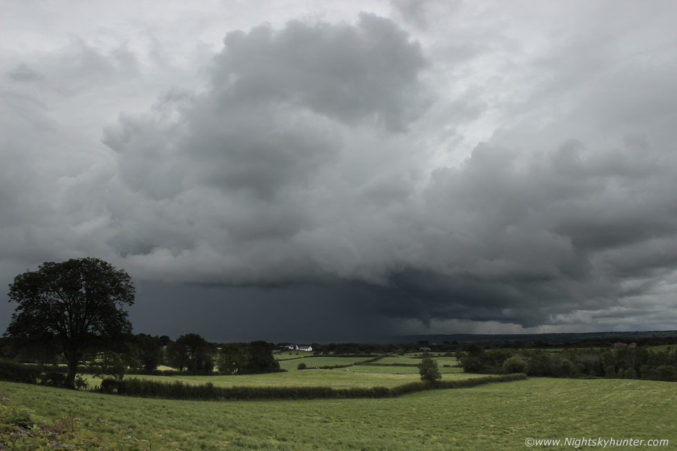
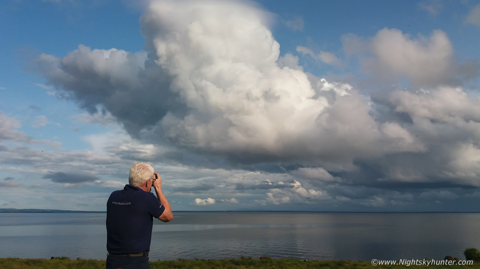
Forty five minutes later a small unimpressive cluster of cumulus formed over the lough, two of these cumulus humulus became more agitated than the others and dominated the cluster. The sun seemed to trigger a reaction and produce lift and slowly these two cumulus began to rise into short cumulus congestus, their edges became more crisp and they seemed to be taking on a new life, we joked about how funny it would be if that cumulus turned into a storm, but to be honest it just looked like fair weather cumulus with some vertical growth bubbling up in the sun using up the last reserve of instability in the atmosphere. However our instincts didn't want to let the matter go, something was going on and we began to get mildly interested. I still didn't think we would see anything but those small clouds were looking photogenic and I said to Nigel ''**** it anyway, I'm going to time lapse those just to get something from this day, maybe I could use it as a gap filler for my end of year video presentation'', so with half a heart I set up the DSLR and began shooting time lapse, really I was doing it just for the sake of doing, I tried to justify it by saying ''I will put it down to a training exercise'', at least I wouldn't be going home empty handed. I could sense Nigel was thinking I was getting a bit desperate time lapsing this and I was thinking the same thing, here's a phone snap with Nigel and the closer cumulus which had now formed a pileus cap, we thought that's a good omen, so Nigel grabbed his camera too, it was pretty if anything else.
 |
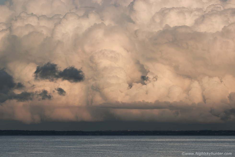
The small tower began to punch through the pileus cap and became more vigorous, new towers formed around the central tower and they began boiling in the sunshine, several cauliflower heads went up and down in cycles then finally they seemed to gather strength from an unseen source and began to ascend rapidly. I was now getting much more interested and was on my second lapse of the scene, main updraught at centre and second updraught to the right further away.
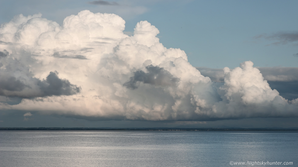 |
As we watched those two towers seemed to merge into one entity then as they crossed further east over the lough they must have tapped into the better unstable air in that area and formed into a cell composed entirely of updraughts. They looked quite stunning, rapid convective growth with hard edges and knuckles on the towers, there was a central updraught and flanking line of towers all merging into a multicell, we watched as several more pileus caps formed, were lifted, then punched through as powerful updraughts soared aloft, it was clear this cell was maturing in a region with better vertical wind shear which was organizing the convection. This was already quite far away on the other side of the lough, the forward flank of this cell was over Co. Antrim while we got treated to the rear flank which is exactly where we would want to be so we couldn't have asked for a better view. I was in the process of shooting multiple time lapse sequences of this entire development, switching over from 10mm to 18-55mm as the cell got further away. The low sun angle illuminated the cell beautifully providing great high contrast clouds against the clear sky background. I was acquiring a lot of images at this point but I didn't want to stop shooting as the scene looked so cool and with flies everywhere in the air and on the camera I expected this lapse would likely be a disaster, I was sure several flies were probably perched on the glass, there was barely a breath of wind so we were getting ate at this point, but I decided to persist with the lapse anyway. Nigel and I marveled at the visual scene, commenting on its real time formation and watched the base for funnel clouds with long lenses at the ready just in case.
 |
When the entire cell moved over Antrim it looked stunning, the updraughts were exploding so late in the evening and the pre-sunset light showed every intricate convective detail in high relief. I switched to the 100-400mm lens and shot a final time lapse of this scene, I knew it looked impressive on the back of the screen and I hoped it would pay off, the camera was taking one image every second, I prayed the tripod wouldn't wobble on the grass with this heavy and unwieldy lens attached.
 |
I would find out later that the prominent updraught at centre was rotating, at this point unknown to us, we where watching a big thunderstorm producing intense rainfall and c-g lightning near Belfast, this was the flanking region in all its glory. Owain Rice observed it from Co. Down and observed a slightly curved horse shoe base and pseudo RFD feature for a brief moment, this cell had greatly benefited from strong wind shear and what a sight it was.
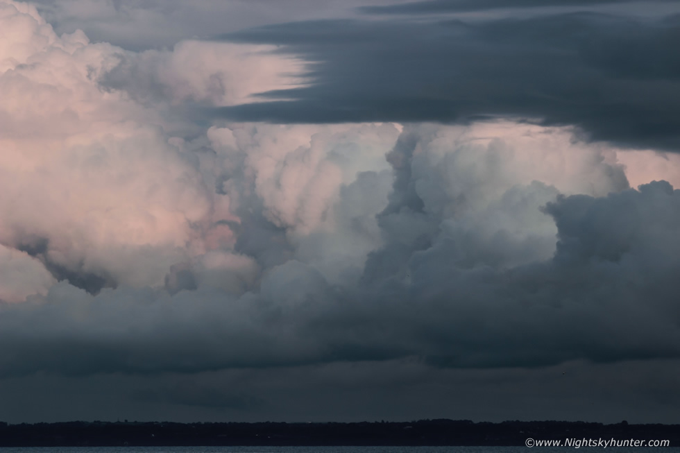 |
Mother nature was painting the updraughts with magical light as the cell vanished from view just as the sun went down. This sure was a nice surprise, we didn't expect to see much this evening but we got treated to a thunderstorm, a distant one, after all. I had been in the presence of five thunderstorms this day and none of them were as beautiful and photogenic as this one. When I got home I realized I had taken over 4000 DSLR images of this convection and when I rendered the time lapse I was delighted with the final video. In fact, this was the best storm time lapse shoot I have ever captured in my life, I documented the entire life cycle of a storm from its birth over the lough as a cumulus to a mature cell all in great light over a long period of time with multiple lenses without so much as a drop of rain on us, and those pesky flies didn't ruin it at all. I honestly can say that there aren't many times when I feel genuinely proud of an image or time lapse, mainly because I always find fault and think things could be done better, but on this day I'm not ashamed to say that I felt proud of this one, it was the photogenic convective moment of the Summer and goes to show that even with your subject far away you can still get great results. Make sure to check out the full time lapse at the bottom of this report.
The following day August 7th was yet another chance for storms, they wouldn't be as intense as the previous day however the set-up looked decent for some fun photo-friendly skies with cells very well scattered and isolated. CAPE was decent, no shear, but convergence would be the key this day and strong solar heating. The flow was from the NW so cells would be better to the S and SE, they would be slow moving with good visibility and with a chance of funnel clouds. Showers broke out by mid day then by 13.00 I was on a local chase near Maghera, I had my Mother and our dog Rhua out for the day to get a nature fix. It was hot outside and in response so such good heating big white towers began going up in rows, I watched them build over the Sperrins then move slowly inland, based on the flow I decided that anywhere from Ballymoney, Kilrea, Ballymena, Antrim and Lough Neagh would be good target areas. One such cell got so tall I knew it had to produce so I gave chase through the back roads hot on its tail, it dropped heavy rain then fell apart, but more towers boiled and the next cell was likely anytime. We pulled into Bellaghy at the local church and got out for some fresh air.
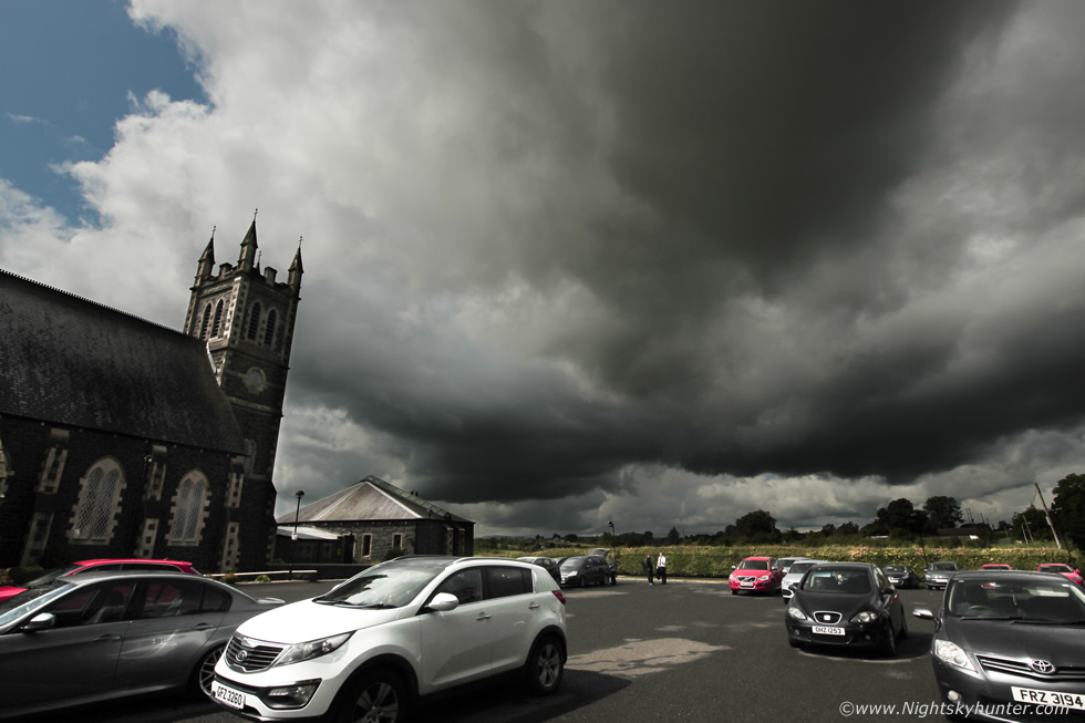 |
A cell built itself together over the fields and slow began drifting our way, I noticed it had a small but compact rounded updraught base and no precip yet so viewing was good of this young cell. Here's a 10mm wide angle capture, I set-up the tripod and shot a short time lapse. Two men came over for a chat and turned out they had an interest in the weather too, one of which explained his encounter with a thunderstorm the previous day which almost flooded his home outside Cookstown. As we chatted and watched this cell passed over the church and suddenly began rotating like crazy, I mean the base was spinning in a frenzy rite over the church roof, we all watched in amazement genuinely expecting a funnel cloud to drop down, we were actually frozen to the spot. Then the rotating area vanished behind trees, a precip core had formed fast then it let out a good rumble of thunder, unreal positioning, we had stopped here just for a break and got rotation and a thunderstorm within five minutes, sometimes its all down to pure luck. We chased the storm deep into the country where it died, I decided to try out a new area and made our way through Toome.
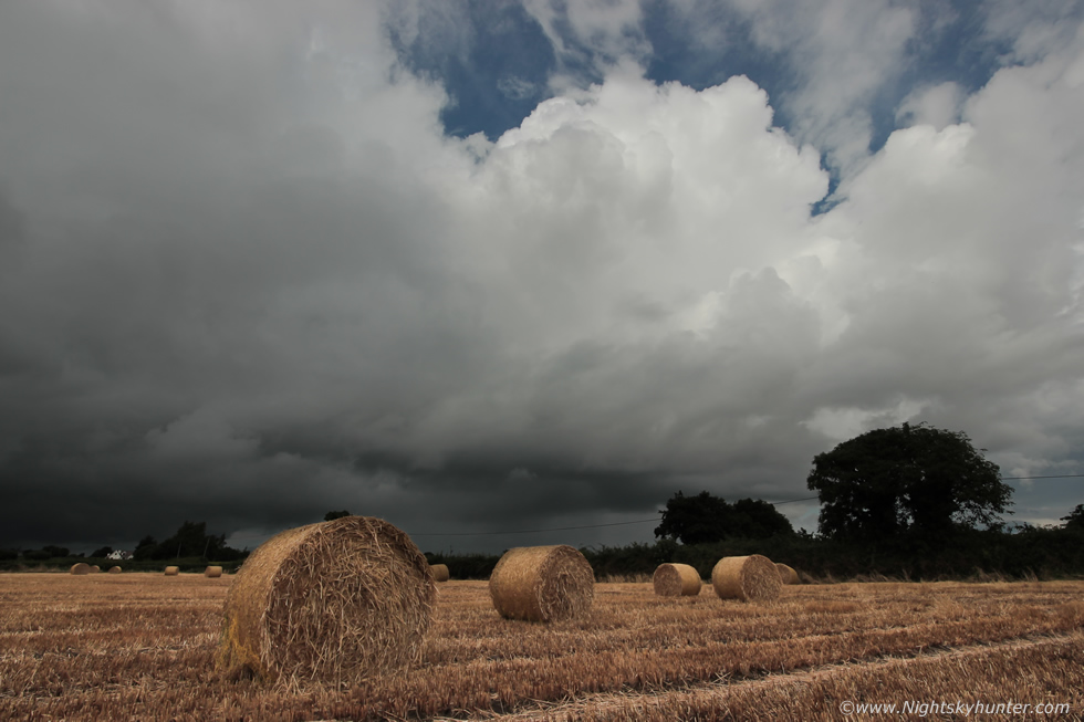 |
Then along the Staffordstown road we pulled into Cranfield outside Creggan on the N shore of the Lough. I had passed a great looking field on the way down to the bottom, a field filled with large round bales of hay. After a short period of observation I saw more towers coming in so I went back to the field and reversed in, I simply couldn't pass up this scene for foreground interest. From this golden field I got treated to four pulse thunderstorms in the area and spent a long time shooting time lapse of the storm clouds over the bales. It was a day of stifling warmth in the sunshine among the hay punctuated by prolific slow moving downpours and thunder.
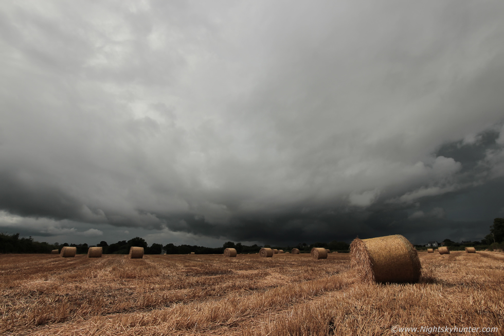 |
These are 10mm stills from various lapses, this was an approaching storm with very low base darkening the western sky while the sun was still casting its light on the bales.
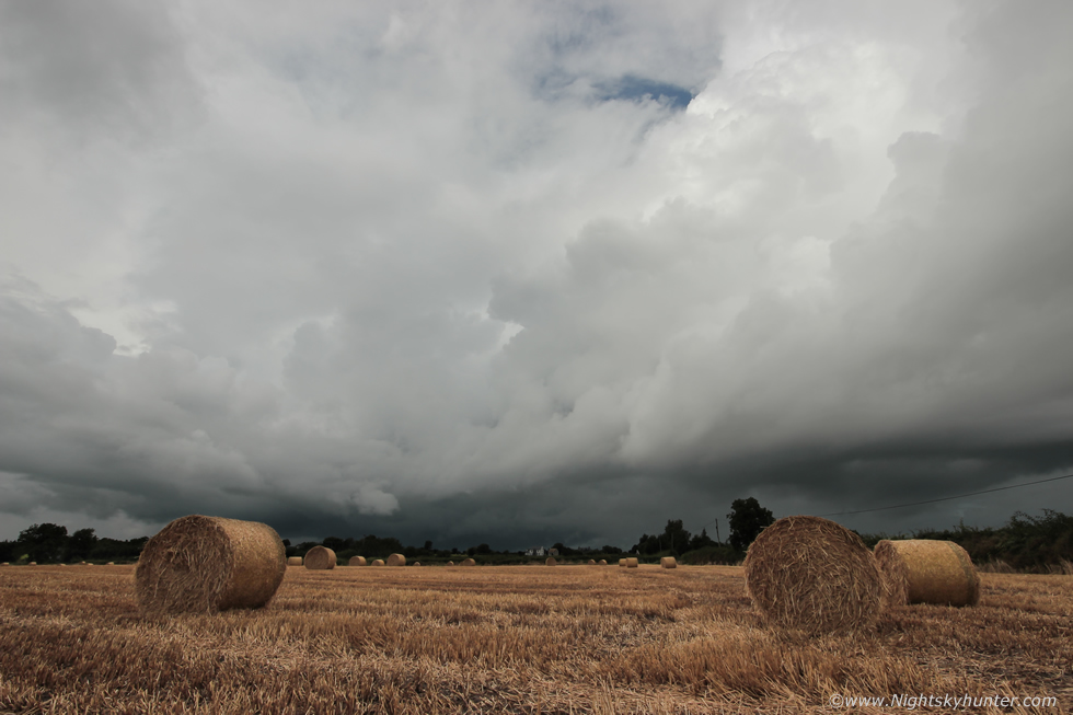 |
Later a side view of a passing cell, moving L to R with convective tops and occasional rumbles. This field was completely water logged however the wet look made the colour of the bales more vibrant and fresh. I didn't know how long I could get away with shooting in this field before the farmer showed up so I made sure to get the most of every minute spent here, the camera never stopped shooting for several hours, it was actually quite an intense time lapse shoot.
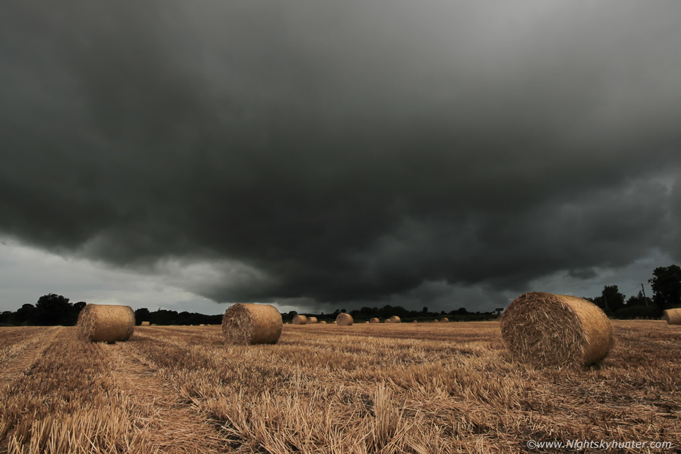 |
Once again I ended up with approximately 4000 images to render, I would have loved for a decent gust front or shelf cloud over these bales however the set-up didn't produce an outflow structure of that caliber this day, this was as close as I got to a gust front, it really was that dark. We re-located to the lough car park then Nigel met us while out chasing and we spent the rest of the afternoon watching for cells and rainbows until the CAPE left the area by late afternoon and we called it a day.
August 6th time lapse of the Lough Neagh cell which matured into the Belfast thunderstorm from birth near Ardboe, best watched at 1080p and opened within youtube expanded window for best experience.
August 7th, various time lapse sequences from the hay bales at Cranfield on the shore of Lough Neagh
This will likely be the end of my Summer chasing in what has been the most trying season I've ever experienced, however during convective droughts there can still be skyscapes worthy of chasing. As I write this we will soon be entering the transition from Summer to Autumn and land based convection will gradually become less frequent and that's when my attention will shift to the coast for the next phase of chasing, thanks very much for reading.
Martin McKenna